8/10/01 Friday
John called and said he couldn't get Monday off work, so he wouldn't be
able to go on the trip with us anymore. This was around 5 or so in the
evening, and Ryan had already left work. So when Ryan got home, we
repacked the food and group gear for two people instead of three. John
stopped by to see us off and wish us well. We left an hour late (7:00).
Because of a landslide in Tioga Pass, which Heidi had informed us about, we were forced to take the southern route through Bakersfield. We had cookies and Gatorade to tide us over until we stopped for supper at McDonalds. Ryan drove while I read aloud from "Summer of the Monkeys" (Wilson Rawls) until eventually it got late and I fell asleep.
We arrived in Lone Pine around 2:30 am. All the hotels were filled, so we looked at Lone Pine Campgrounds for a site. There were several empty spaces, but all were reserved. The reservation on one site was to expire the next day, so we just hijacked that one and got to bed by 3:30 am, forgoing the tent and just sleeping out under the shooting stars.
8/11/01 Saturday
Ryan woke me at 7:10 in the morning. We hurried up and got out of there
before any ranger came by to see us in someone else's campsite. The
Whitney Portal Store was a quick drive away (trail head is there),
where we had planned to eat breakfast. The pancakes were recommended by
some folks on the Portal Store web site message board, but nothing had
prepared us for the size of them. The Pansan meal looked good--2 eggs,
4 bacons and a pancake for $4.95 (except that we got charged $6.32
apiece--tax?). The pancake was about a foot and a half in diameter and
three quarters of an inch thick, with about a quarter cup dollop of
butter and the eggs and bacon all on top. I got the eggs over easy,
three yolks meant three eggs instead of just two. The guy had made
Ryan's eggs over easy too before noticing his order was for scrambled.
So Ryan got six eggs! and 4-5 strips of bacon a-person. We couldn't eat
even the most respectable fraction of our food.
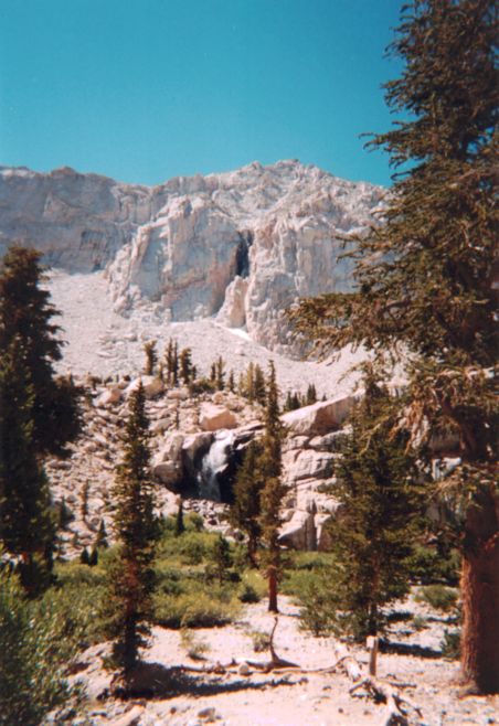
Earlier, Ryan had realized that his hiking poles were still at home in San Jose. There were free demo poles at the Portal Store, but only one left, so Ryan ended up buying new ones at the store. Finally we hit the trail at 8:30. (8,367 ft.) Our packs were heavy and grew heavier. It seemed that we climbed a long way, but made good time. We reached a meadow with a pretty waterfall, that some idiot said was halfway--without too much pain. (Later, Ryan said the guy was telling the truth. Hmph.)
The second half, then, was terribly cruel. We kept going slower and slower and our heads began to hurt. We stopped for a snack, then filled our water bottles with new water at Mirror Lake (10,640 ft.) and had the rest of our lunch a little later after that. The Crystal Light was too strong, then too weak later when I diluted it. (The Cytomax turns out to be delicious and just the cure for a headache, too. Peachy Keen is the best flavor so far.)
Our rests became more and more frequent towards the end, and the end continued to be just out of sight. Returning hikers kept saying, "You're close," but soon I got the impression we weren't at all. When our feet were hurting something awful and we were flagging in our will to carry on, we came upon an excellent feet-soaking place: A cold stream with deep pools and perfect rocks beside for sitting while your feet are cooled in the water. We dallied a little bit to soothe our soles, then donned our boots and trudged on once again. (On the way back down, when we were tired and silly, we came up with the plan of just staying on the mountain and living in a small crack in the rocks near this place, where we would exchange food from returning hikers for the permission to use our feet-soaking pool. Of course, we didn't do that.)
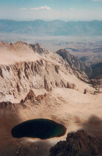
At last, at the top of one steep climb I had felt was supposed to be in the second day's hike, I saw the lake that was a half mile from Trail Camp (Consultation Lake). From there, camp wasn't close, but was close to being close.
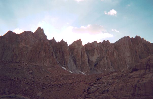
Upon arrival, we located a suitable site, pitched the tent and took a long, hot, dizzy snooze. Only after waking (reluctantly) and making supper and drinking Cytomax did our spirits return. (Trail Camp, 12,039 ft.)
Dark clouds that came during the afternoon went without rainfall upon arrival of evening. After supper, at dark, we turned in, intending to wake around midnight to watch the stars and the Perseid meteor shower.
8/12/01 Sunday - The wee hours
We did wake at just past midnight. The sky was black and the stars
brilliant white, until the moon rose and the sky began to lighten. The
red rock cliffs surrounding us reminded us of Mars. Of course, we have
never been to Mars, and there was more of a sci-fi feel to it, what
with the small pond and surrounding greenness like some Martian oasis,
but the effect was so alien. We lay outside on a flat rock in our
sleeping bags about half an hour watching the meteors fly overhead.
Some were incredibly bright and thrilling to watch. A couple had trails
that covered a quarter of the sky.
After returning to sleep, I was awakened by a rustling noise coming from my pack. The plastic bag covering it was crinkling back and forth and in the dim light, it looked like there was a shadowy creature before it, nosing about.
After I felt sure there was really something there, I woke Ryan to look quietly out the tent window at the small bear I assumed it must be. We looked for a hard while, but there turned out to be nothing there, for which I felt foolish. Poor Ryan, too, who couldn't get back to sleep after that (not for fear of bears, though!--but because the night was just generally uncomfortable and the ground hard and tilted.)
In the morning, we prepared and ate a small breakfast of instant oatmeal and hot chocolate.
8/12/01 Sunday
We started out at 7:30, up the hill. The path was gentle in the
beginning, then smoothly segued into the switch backs. They're called
the 99 Switchbacks (some places the 100 Switchbacks also, I think).
Anyhow, I tried counting them on the way up, but lost track at 20 or
so. (We did count them on the way down. I didn't realize the name "99
Switchbacks" wasn't euphemistic and figured there were probably more
like 60 or so. Ryan said there were 97-100 of them based on other
people's figures. According to our count, there are 98 reversals of
direction.) As we climbed up the switchbacks, we took to trying to see
what new lakes and ponds appeared as we got higher. One "secret" pond
was so chilly-cold looking, all blue-green and icy, with white snow
filling half of it. As we climbed, camp got smaller and smaller until you couldn't see the tents at all.
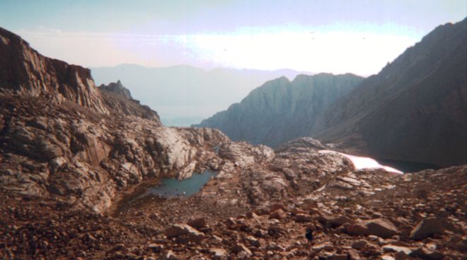
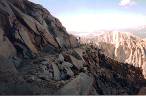
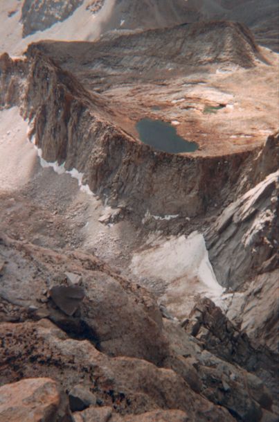
After the 99 Switchbacks, we were at the top of the ridge on Trail Crest (13,777 ft.). From there, it was supposedly just cross- walking (horizontal mostly--little ascension, that is) but really, there was plenty of climbing left to go. First, rudely, the trail took us down the other side of the mountain (Mt. Muir) then back up again further on over. The view at least was nice. Over the ridge we could see pretty far into the Sequoia National Forest and the mountains that bordered the western edge. The peak of Whitney disappeared as we traversed the trail on the back of the ridge, until at last we could see the summit hut far off, but in sight.
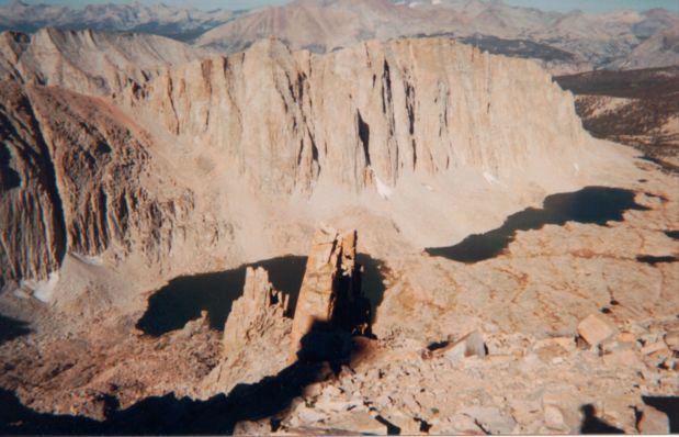
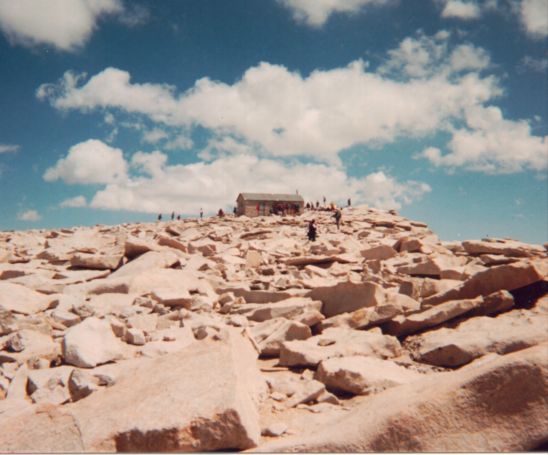
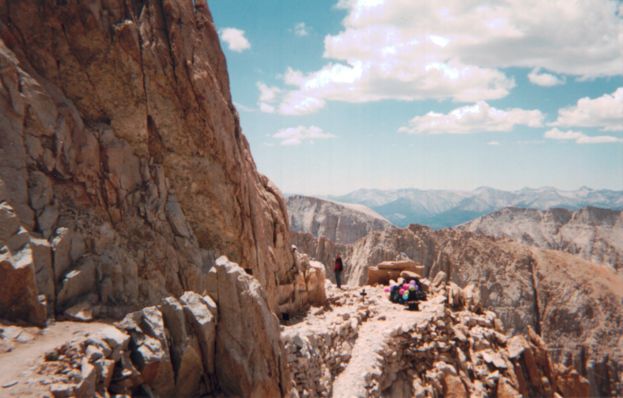
Nearer the top, as we hiked up the last hill, the trail got lost in the large boulders and rocks. People were wandering aimlessly on that final face, clueless of the actual direction to go but up somehow. Ryan spotted several stone towers (3 stones stacked up) marking the trail. Soon, finally, we made it to the top. (11 miles walking, 14,497 ft.)
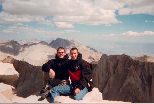
8/12/01 Sunday - At the top
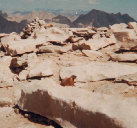
We lunched and rested, took photos and signed the summit log at the hut. Other
hikers were chatting on their cell phones. One hiker had brought some
freeze-dried ice cream that he didn't really like. He gave some to us
and left the rest on a rock for the marmots. The marmots didn't eat it.
Ryan spent a good deal of time climbing out further and further on the edge of the nigh infinite drop-off to get a good picture looking straight down.
After resting, we made our way back down. The "flat" part along Trail Crest was less pleasant, because of the number of times we had to go up on the way down. At the junction near Trail Crest, we passed some packs that had been lightened by the helium balloons tied to them. At the 99 Switchbacks, we counted each time we turned to the other direction going down.
When we returned to camp, I stuck my feet (bare) in the ice cold pond. I really wanted to plunge my whole self into the water, but One, it was dirty, and Two, I had no suitable bathing gear, so I settled for feet only. My ankles were feeling very swollen above the boot cuff for some reason.
The day was hot, and I could foresee an unpleasant evening ahead, of digging through cramped backpacks and a cramped tent. It was only 2:30 (summit at 11:00, lunch for an hour then down by 2 o'clock followed by a half hour of resting). We figured if we could get the camp packed up by 3:00 we should hike out that day and spend a better evening relaxing in an air conditioned motel. Camp was packed up by 3:30 (a little late) but we left anyhow.
All along I'd been thinking that the Portal Store was at 8900 ft., and Trail Camp was at 11000 ft. elevation, so we'd have only about 2000 feet to descend with packs (heavier than we planned to have on the way back with fuel and food for an extra day still remaining). It turns out Trail Camp is around 12000 ft. (12,039 ft. really) and the Portal Store (at the base of the trail) is actually at 8400 ft. (8,367 ft. really), almost twice what I was figuring!
Boy did our legs ache going back down. It took us about 3 hours to make it back. (Really, we arrived at 6:35 or something like that. Just barely longer than 3 hours.) When we arrived at last, hungry and tired, we had supper at a pizza place in town (Lone Pine--I can't remember the name of it, but I remember their slogan: "We toss'em, They're awesome!"). Then we found a cheap motel in Lone Pine (!!) for $35/night (vs. $52 and a shared bathroom). It was off the main road and a bit hard to spot, which explains the price a little better. (Timberlake Motel.) The air conditioning had been turned off, and the room was blistering hot. All the surfaces were hot to the touch, so we checked out the local gift shop while the room cooled down.
8/13/01 Monday
On Monday, since we had already descended, we caught breakfast at
Carl's Jr. (breakfast burritos--need more cheese) then drove to the
nearby Ancient Bristlecone Pine Forest. ("Go to town, head north 15
miles and look for the signs," the guy at Whitney Portal Store said.)
The forest is actually farther than that. 15 miles north is
Independence. 25 miles north of that is Big Pine. From Big Pine,
another 25 miles east gets you to the turn off for the National Forest,
upon which it's about 5-10 miles north still to get to the ranger
information station.
The ancient bristlecone pines are the oldest living trees known on Earth (oldest living things, even?), many of them over 4,000 years old. There is a Methuselah Grove with "Methuselah," the oldest tree of all, but the specific tree is unmarked in the grove (to protect it) and the grove is a 4-mile round-trip hike from the parking lot. Our legs and feet were only interested in one mile, so we took the 1-mile circuit through a different portion of the forest, but the sights were still extraordinary and we saw some of the 4k'ers--gnarly, twisted old trees.
The drive home was uneventful, except that we took the southern route again because the landslides weren't cleared up yet. We passed Lake Isabella on the way back (a slightly different route than on the way in) and stopped for a swim in the Kern River, which was refreshing.
Danny
Additional pictures:
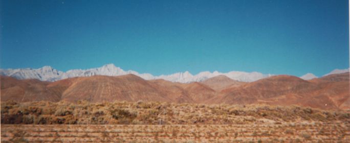
Mount Whitney (in the center) from Highway 395
Total distance: 22 miles
Total elevation gain: 6130+ feet
Maximum elevation: 14497 feet (Mount Whitney)
Highest peak in the continental United States
Other trips