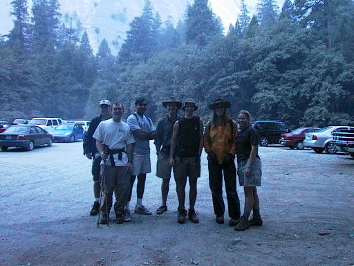
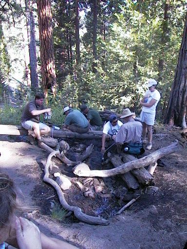
Compared with other recent trips, this was a big one. The group consisted of Danny, Shad, Alay, Tim, Rochelle, John, and me. We left the Bay area in two cars, an early group with Shad, Alay, Tim, and Rochelle, and a later group with Danny, John, and me. The early group turned out to have worse traffic problems than the later one, which left at 6pm. My carload arrived at the campsite around 11pm. The early group had gotten there about 4 hours ago, and had graciously set up camp and started a fire by the time we arrived. I'd been unable to obtain any permits for sites in Yosemite Valley, so we were camped in Crane Flat, which is the best alternative. We had two campsites, but ended up staying in just the one. As soon as we finished unloading the car, we hit the sack, because we were planning on getting up at 5am.
We started moving around at 5am, but it took us a while to actually get started. We had a cold breakfast to save time, and managed to get out of the campsite just before 6:30. We drove down to the trailhead near Happy Isles, and hit the trail at 7am.
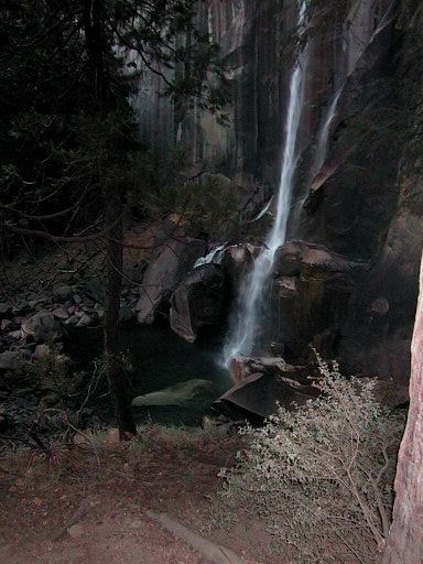
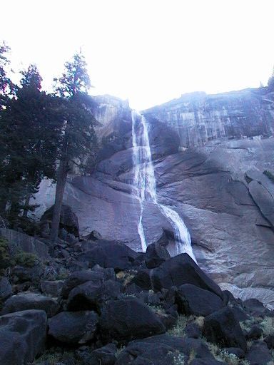
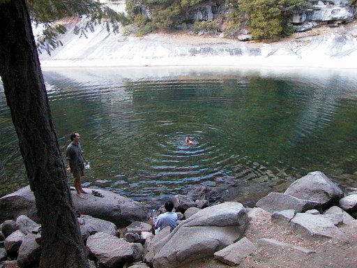
The trail started out by following a service road to the Happy Isles Nature Center, then crossing a bridge to the actual trail. A very nice large metal sign with a map marked the beginning of the Vernal/Nevada Falls trail, which was the first segment of our hike. The initial part of the trail was paved, but fairly steep. The carb rush from breakfast (bagels, cream cheese, lox, donuts, and OJ) wore off quickly for most of us. When we got to the fork for the Mist and Muir trail, we took the Mist trail as we had planned. It was supposed to be steeper, and wet, but almost a mile shorter. Since it was late summer, it turned out not to be wet at all, but it was still very steep. After a bit, the trail turned into a long staircase, with stairs built out of blasted granite. The stairs wound their way along a cliff, under a boulder archway, and up to the top of Vernal Falls. The falls themselves were not very impressive due to the lack of water. Only a small stream tumbled over the cliff where a twenty foot wide torrent exists in the spring. At the top, there was a neat area with a handrail guard where you could go very close to the edge of the falls and look over. Just upriver was a beautiful lake with a far shore of pure white granite sloping into the pool. At the other end of the pool, a stream came down a fun-looking granite waterslide. Signs warned of getting swept over the falls if you went wading or swimming, but this was obviously not a danger with such low water levels.
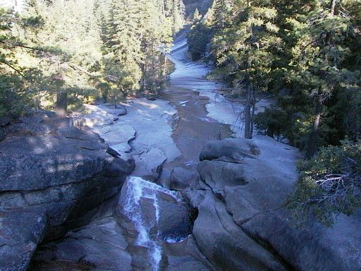
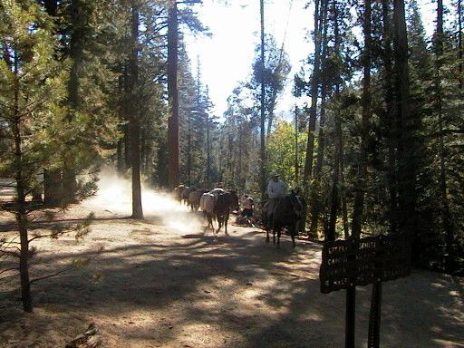
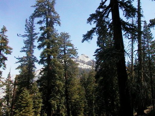
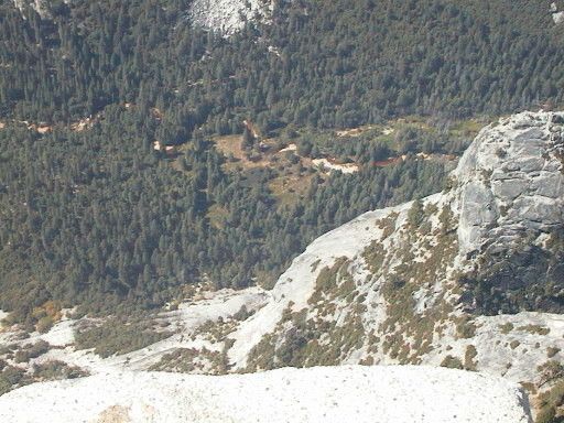
After a brief rest, we started up again, this time toward the top of Nevada Falls. The steepest climb was behind us though, and we zig-zagged our way up along the side of a canyon without much difficulty. Shortly after reaching the top of Nevada Falls, we entered Little Yosemite Valley. The trail was flat through the valley, but consisted of sand and loose dirt several inches deep, so the going was not as easy as I had expected. Shortly after entering the valley, we came to a fork in the trail right next to the river. We rested as a fully laden pack train came by, stirring up a lot of dust. It was extremely dry and dustly along the trail, and back at the campsite. Everything was getting dirty. Anything you dropped was covered in dust when you picked it up. From the fork, we got a good view of the backside of our destination.
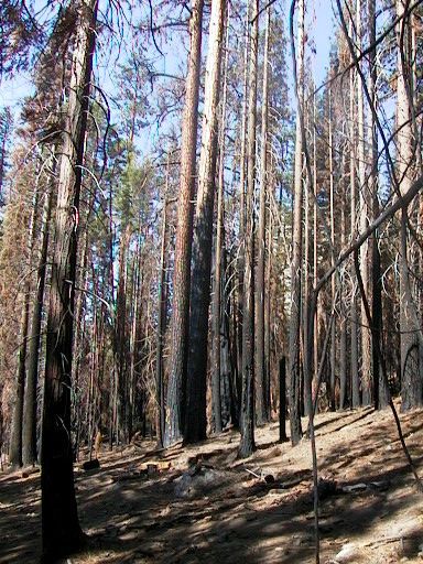
We continued on, and after passing the backpackers camp, the trail took a sharp left and began to climb a forested slope. Partway up the slope, we ran across a muddy hole containing a stream. This was the last good water. A bit further up, a section of the forest was burned. I'd been keeping an eye out for a spring which was marked on the map, but I missed it here. On the way back, we found the side trail leading to it, but it was smaller even than the muddy hole. We rested and took some pictures on a log.
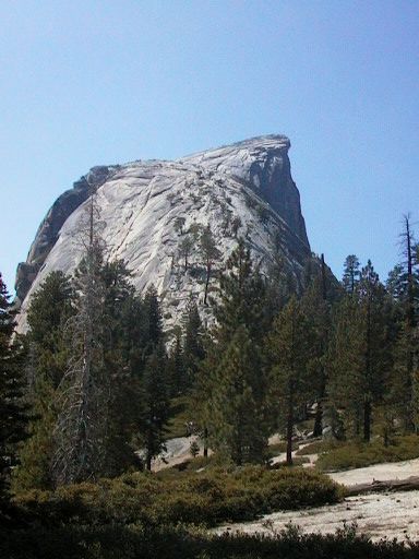
After a bit longer, it was getting to be noon. I'd been hoping to have lunch near the cables, but it looked like that wasn't going to happen. Also, from what I'd seen in Little Yosemite Valley, it looked like there was not much in the way of shade near where the cables started. Energy was waning and some people were hungry so Danny and I started looking for a spot. When we got to the top of the ridge, we had a great view of the side of Half Dome and into the main valley, so we decided to eat there. It was a popular spot, but there was plenty of room. However, there were also plenty of yellowjackets which seemed to want our sandwiches as much as we did. No one got stung though. We broke out the Cytomax. It was Juicy Peach again, but this time from a bulk container. For some reason it didn't taste as good as it did coming from the individual packets. Even when I added more mix to make it stronger, the taste was still not as flavorful. But it still did a good job of recharging us. From here, I could look back toward Clouds' Rest, where Danny and I had hike about two months ago.
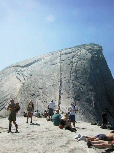
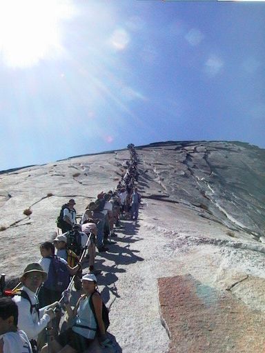
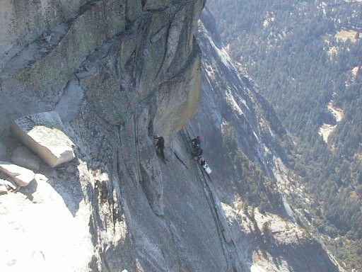
There was a short but brutally steep climb just after the lunch spot, and these seemed to take away almost all of the energy we gained. Fortunately, it was followed by a flat spot, which lead to the base of the lower part of the dome. From here, the trail got steep, going up in short, narrow switchbacks, which were sometimes no more than stairs. The going was slow because the trail was only wide enough for one person, and there were people going up and down. Also, people tended to move very slowly, both from being careful and being tired. The views were great though. The tree cover was almost all gone, and we were walking up a narrow ridge, giving us views on both sides. After a tiring climb, we got to another short flat part. From here we could see the cables. A line of people streched from the bottom all the way to the top, not moving at all. A large number of people were sitting or lying around on the rock. We rested a bit and waited for everyone to arrive before we started up.
At the base of the cable, there was a pile of about a hundred pairs of gloves, most with holes ripped in them. We put our own gloves on or selected a pair from the pile, and got in line. There was a pair of inch thick wire cables which ran through posts stuck in holes in the rock. Usually each pair of posts had a small board running between them, across the path, so that you had a place to rest. Every once an a while, the cable was anchored and a new cable started. Almost everyone climbing up was inside the pair of cables, which was about 3 feet wide, except for a few standing outside on the right. No one going up was moving that I could see. There was a small trickle of people coming down, both inside the cable and outside on the left side. It was unclear why the line going up wasn't moving. We waited, and after several minutes, the line moved forward about 10 people's worth, which put some of us on the slope of the dome. We waited another several minutes, and line did not move. Maybe people coming down were not yielding right of way to those going up, as they should be doing. Or maybe there was someone very tired toward the top, who would not step out of the way. Just standing there on the steeply sloping granite, holding on to the cables was tiring on the arms and painful on the ankles. Eventually a few climbers ahead of out decided to go on the outside of the cables, to the right. It looked like the climb was OK, even when it got a bit steeper, and no one was in the way there, so we did the same, going quickly up on the outside right side of the cables. An equally quick group on the outside left was going down. Congestion continued in the center. When I got to the top, I was tired, and forgot to look for the exact cause of the traffic jam. By the time I remembered, the line was thinned out, and I couldn't tell.
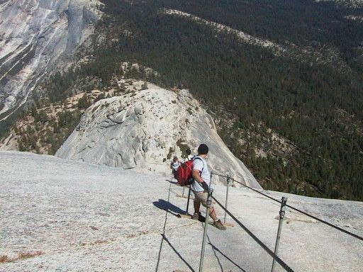
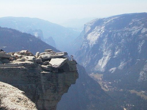
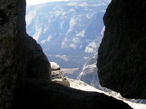
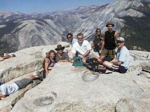
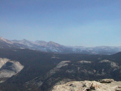
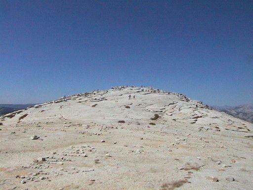
The top of Half Dome was much bigger than I expected it to be. Most people were clustered on the high point overlooking the valley and the slope leading up to it. A huge area over the the side was virtually unpopulated, although it did have several small stone piles and artworks on it. This unpopulated area also had a layer of dirt, which seemed strange, while the rest of the rock was bare granite. I would have expected all the dirt to have been washed or blown off. I proceeded up the slope and met Shad and Danny who had gotten up first. We waited there while the rest of the group climbed up. The view down over the edge was spectacular. From one vantage point, there was an outcropping which was not obvious from the valley below. Looking down, we could see a group of climbers which was about 50 feet shy of the top. It took them a long time to make even a small amount of progress. We headed down before they reached the top. We took some group photos, admired the view, and some people rested while others wandered around. There were about 150 other people on top, but it didn't feel crowded at all. It was a lot like a beach, because it was hot and sunny, and lots of people were lying around, many with shirts off.
After a total of 30 minutes on top or so, we decided to head down. We had a long hike ahead of us, and it was already after 3pm. The cables were still very slow going down, so again we took the outside route. By this time we were all out or almost out of water, so as we began to meet up at the bottom of the zigzag path, some of us went ahead at a faster pace to find the closest water we could and start filtering it and filling bottles. We found the stream I'd been looking for earlier, but it was useless, so we used the little stream by the side of the trail. It was actually not so bad once you took a close look at it. As we were filling up all the water bottles, other groups came by and started doing the same. Eventually we had three groups at once taking water from this small stream. As we were finishing up, the rest of the group arrived and we had a rest and drank a lot of water. Shad and Alay were interested in taking a swim at the top of Vernal Falls, so they went on ahead.
Our trip down was pretty uneventful. Once we got to the top of Nevada Falls, Danny and I went ahead so that Danny could have a chance to wade or swim. By the time we'd all joined up at Vernal Falls, the sun was getting ready to go down. Rochelle was also interested in a swim, so she stayed behind with Alay and Danny. They had two flashlights, so would be OK in the dark. The rest of us started down. By the time we reached the paved section at the bottom, it was starting to get dark. By the time we reached the trailhead, we could barely see. There was just enough light to see whatever obstacles were at our feet, but no futher. Shad stayed at the car park to wait for the rest of the group, while the rest of us drove back to the campsite to start dinner.
We had a fire started and everything out and ready to cook by the time the other group got to camp. We were all tired, so the meal was somewhat abbreviated. In the morning, we had a wealth of food available for breakfast. We packed up camp and split up again. Shad's car planned to tour Yosemite for a bit, while my car was going directly home (Danny and I had to prepare for a Blink 182 concert that night).
And so the last trip of the summer was over. Little did we know that the happy glow of the weekend would soon be shattered by death and destruction, which seemed so unreal.
Total distance: 16.4 miles
Total elevation gain: 4800 feet
Maximum elevation: 8842 feet (Half Dome)
Other trips